So, for the few of you out there who are reading this, I apologize for being behind in posts. I just realized that the last post I put up here was from Monday, and it's already Saturday night.
If you've been looking at my flickr photos here:
http://www.flickr.com/photos/lawsonphotos/collections/72157600510437290/
then you have some idea of what we've been doing. If not, here's a very brief recap (it's 11:30 PM and we have 10 hours of driving tomorrow to Idaho)
Monday - We walked around town and did some shopping and went to a concert in the park in the evening (see previous post).
Tuesday - Adam (my brother-in-law), Jane (my aunt), and Derek (my cousin) and I went golfing down in Gunnison. Sarah went with my parents and sister up to a place called Lake Irwin. While I was golfing, I stepped in a hole and twisted my ankle. I originally thought that it was sprained, but it got better quickly. There are photos of both events on the flickr page.
Wednesday - In the morning, Amy, Adam, and Heather (my cousin) walked and Martha (my aunt), Ted (my uncle), and Gary (another uncle) ran the 8 mile walk/run from Gothic (north of Crested Butte) to the town of Crested Butte. Then immediately afterwards there was a 4th of July parade in town. That evening, we went down to the town to see the fireworks. My ankle was still a little sore, but much better. I was at least able to walk on it without limping.
Thursday - Sarah decided to hang out in the condo and relax, while I went with Martha (previously mentioned aunt) and Heather (previously mentioned cousin) on an approximately 11 mile out and back hike (so about 5.5 miles each way) that went up about 2000 feet of elevation. We turned back a little early because it looked like rain ahead of us, but while we were heading back, we got hit with another storm cloud...quite a bit of rain, got very cold, then started hailing (Colorado hail is much smaller than Illinois hail, it felt more like sleet). We eventually made it back to the car, cold and wet, but I felt a lot better once we got back to the condo and I got a warm shower. My ankle was fine, but I was favoring my right ankle so I wouldn't put more strain on my left (the previously mentioned hurt ankle) and ended up making my right one a little sore.
Friday - In the morning, a bunch of us took a ski lift up to the upper part of Mt. Crested Butte. We started hiking up the rest of the mountain, but only me, my dad, and my sister, Amy made it to the summit at 12,162 feet above sea level, the highest point I've ever been to. Even though the lift took us up about 2/3 of the way to the top (maybe closer, I'm not sure), the rest of the hike was pretty steep (for us Illinois folks) and was hard, although it was pretty much just rocks for the top few hundred feet, and that was actually easier since they didn't slide as much as dirt. On the way down, there was snow, probably at around 12K feet, so I grabbed a snowball and put it in an insulated lunch bag that I had with me...more about this later. After we made it back down, we relaxed at the condo a bit, and then drove up to Taylor Reservoir (big pretty lake) for a look around.
Saturday (today) - we left Crested Butte in the morning a little after 9 AM. We drove from Crested Butte to Green River, Utah, only about 260 miles, but we planned on making quite a few stops at scenic places. Technically, we drove through or stopped and saw four national parks/monuments/recreation areas.
Driving west from Gunnison, we drove through the Curicanti National Recreation Area, which is essentially three large lakes that are formed by a dam in part of the Gunnison River.
After that we stopped at the Black Canyon of the Gunnison National Park, a very deep canyon formed by the Gunnison River. After that, we continued west through Montrose, CO and up to Grand Junction, CO.
Near Grand Junction, we stopped at Colorado National Monument, which was formed when erosion ate away at Monument Mesa and formed huge rock formations.
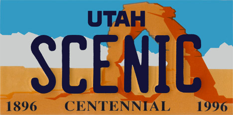
We then headed west some more into Utah, then south to Arches National Park. Similarly to Colorado National Monument, Arches is a large area where erosion created amazing rock formations. If you've seen a Utah license plate, you've seen one of the formations in this park (here's my photo of the same formation from the other side). We were in Arches fairly late in the day, showing up around 7:30 and staying until about 9...even so it, was over 93 degrees the entire time we were there. So, taking the previously mentioned snowball from Mt. Crested Butte, we decided to see what a snowball's chance in hell really is. Here's the before and after pictures. It started melting immediately, but when we came back past about an hour later, there was a tiny bit of ice left, and a small puddle. So, I suppose it's chances are decent for less than an hour, but longer than that, and you've just got a small wet spot.
Anyway, after all that, we headed back up the road to Green River, Utah
where I am writing this from right now...and seeing as it's 12:05 (1:05 AM Central Time), and we're getting up at 6:30 to get on the road early for the long drive tomorrow (Sunday), I should get some sleep. I hope this catches everyone up, if you have any questions about what all we did, I'm checking my email pretty much each evening, and you can email me at LawsonST@gmail.com. As always, the previously mentioned photos, as well as many more (but not all, I've taken 2,237 photos since we left Illinois, and despite flickr's claims that I have unlimited storage, I don't want to subject any of you to all of the photos, which is why I'm only posting a few of the best ones) on my flickr page and hopefully I'll keep up with this blog a little better now that we're on the road again. G'nite.
No comments:
Post a Comment