Almost home...it's starting to look and feel a lot more like home. There's corn...humidity....and a Hy-Vee in Lincoln, NE. Tomorrow it's the final leg of our journey, through Iowa and back home.
So, here's a bit more details about what we did over the past three days...other than driving.
Sunday we started out from Portland. One of the few photos from Portland is this, which is a floating restaurant that we ate at the first night we were there.
While driving across Oregon, we passed by the tree farm I mentioned before, here's a photo of that. In case you can't read the sign, it says Planted - 1998, Harvested - 2006, Replanted - 2007. So, in the 8 years that the trees were planted, they grew from the tiny seedlings you see here to the tall trees in the background that were ready for harvest.
Something I didn't believe the first time I saw it was this....corn in Idaho. They do actually grow it here...it takes a lot of water and smart irrigation to make it happen, but it grows.
Yesterday we started out in Twin Falls, ID...so named because of the Snake River running through a canyon just north of town, with waterfalls in it. This is Shoshone Falls, about 5 miles upstream from Twin Falls. The photo doesn't make it look all that impressive, but it's actually taller than Niagra Falls, you can click here for more info about it. Here's another photo with a rainbow in the mist. You might recognize the name Snake River from an unsuccessful jumping of the canyon by Evel Knievel in 1974.
The main bridge across the river is the Perrine Bridge (photo), which is apparently the "only manmade structure in the US where BASE jumping is allowed year round without a permit". And wouldn't you know it, a couple of guys were just heading out there to do just that when we were getting ready to leave. In case you don't know what BASE jumping is, it's like skydiving, only you jump off something that is attached to the ground, like a building, cliff, or in this case, bridge. So, I got a few shots of the second guy jumping off the bridge. In case you are wondering, yes, he got his parachute open in time.
One other thing, there is a golf course that crosses over the snake river that is entirely contained in the canyon, just west of the bridge. So, this photo's for Adam (my brother-in-law).
In southern Idaho, we passed by a wildfire that had burned some of the brush up close to the road. By the time we went by, it was pretty well contained though, this was about all that was going on with it.
After we crossed the border from Utah into Wyoming, we stopped at a state park/rest stop that had some of the local wildlife. We saw bison, baby bison taking a nap, elk, and a seagull (don't ask me, the nearest large body of water is the great salt lake, and it was a good 50 miles away, over a small range of mountains).
Other things we saw that day...pretty flower in the Utah desert...lots of long stretches of road...and frequent window cleanings. We finally got into Cheyenne, WY about 9:30 or so local time.
Today we drove from Cheyenne to Lincoln, NE. As I mentioned, this afternoon started to look a lot more like home. So, starting in one state capital (Cheyenne is the capital of Wyoming), and driving to another (Lincoln is the capital of Nebraska). I plan on getting the photo of Nebraska's capitol building tomorrow morning before we leave if possible.
Near Kearny, NE, we stopped at the Great Platte River Road Archway. It's kinda a museum/tour of the history of cross country travel starting with the Oregon/Mormon/California trails, through stagecoaches, railroads, dirt roads, paved highways, and interstates. Here's a few of my photos from it: Photo 1, Photo 2, me in front of a bison sculpture, replica covered wagon (message seemed fitting), sign from the nearby Lincoln Highway marking the point equidistant between San Francisco and Boston, window looking out onto I-80, another photo of the building from the road.
Finally, somewhere outside of Lincoln, NE, we hit 40K miles on our car (it was a bit over 33K when we bought it). Don't freak out about the speed, out here that's called keeping up with traffic (and it's not much over the speed limit either).
Well, that's where we are as of today...Lincoln, NE. As I said, tomorrow night, we'll be home...and we are ready to be home....not necessarily ready to go back to work, but definitely ready to be home. We should be back in town around 8:30 or 9....we plan on making a side trip up to Dike, IA (near Cedar Falls/Waterloo) to see Sarah's grandmother.
G'nite.
Tuesday, July 17, 2007
Monday, July 16, 2007
It's pretty late, so....
I'm not actually going to post much here tonight, since we drove all day and I'm pretty tired. I did post some photos to our flickr page from the last few days, so you can stop by and check those out. Other than that, I just wanted to let everyone know that we're on our way home and doing fine. Tonight we're in Cheyenne, WY, and tomorrow we drive to Lincoln, NE. Less driving, but we plan on stopping at the Great Platte River Road Archway and Museum, so that'll take a couple of hours.
We should get into our hotel a bit sooner tomorrow night, so I'll try to get on and post more details about our drive back then.
G'nite.
We should get into our hotel a bit sooner tomorrow night, so I'll try to get on and post more details about our drive back then.
G'nite.
Tuesday, July 10, 2007
Day 11 - Off to the sea
So today we drove to the ocean and back. We're staying in the same hotel tonight as last night...it's nice being able to leave your stuff somewhere for a day, so we didn't have to worry about driving to anywhere. Our route took us north to Kelso, WA, west to Astoria, OR, south to Seaside and Cannon Beach, OR, then south the Tillamook, OR, and finally, back into Portland. To see our route, click here. Each of the yellow pause icons are places we stopped, except the first one, that's just to get the route correct.
The first place we stopped was in Seaside, OR. We walked out to the ocean for a little and walked along the water....it was really cold. Anyway, I didn't take any pictures here, I saved that for the next stop.
Next we drove down to Cannon Beach, OR and pretty much did the same thing, walking along the beach for a bit. The sand was very hot (it was about 100 degrees out here today...about 20 degrees higher than is normal), but the water cooled it off quickly...so as long as we walked along the wet sand or in the shallow water, it wasn't too bad.
At Cannon Beach, I did take a few photos, since there are some interesting looking rock formations nearby. I took this photo of Sarah at the ocean, and then this shot of both of us. In case you couldn't tell, I'm getting a little tan from all the time outside in the sun lately.
There were quite a few seagulls, so I shot some photos of them: bird with an itch, low flying seagull.
Then I shot some photos of the rocks around Cannon Beach, this shot is looking north up the beach, and this shot is of one of the more recognizable landmarks along the Oregon Coast, Haystack Rock at Cannon Beach...it's looking south from where we were on the beach.
We then continued south and stopped at a couple of scenic overlooks taking this photo, and this photo.
We then got to Tillamook, OR, known for it's cheese factory. They have self-guided tours, windows where you can look down on the factory floor, and a cafeteria/gift shop where you can buy cheese, ice cream, or other Tillamook Cheese merchandise. It was a pretty impressive operation, but I still think there's something to be said about making cheese the old-fashioned way like we saw last summer in Wisconsin. Anyway, we bought some cheese, and some curds that we ate on the way back to Portland. They were decent...again, not as good as Wisconsin, but the were at least squeaky...the way fresh curds should be.
Then we drove back into Portland, about 30 miles of it through a state forest, which was pretty windy, but was nice and shaded most of the way. We got caught in some of the rush hour traffic heading north out of the downtown area on the way back through though, so it took us about 15-20 minutes to move two miles at one point, but it wasn't too bad...our car's air conditioning is still working great thankfully.
Anyway, that's about all we did today, got back to the hotel at around 7ish, our time. Tomorrow it's off to our hotel downtown, and time for my meetings and business stuff. It's kinda like it's back to work, but not exactly. I like to think of it as easing myself back into work, then getting another four day break as we drive home. I'm not sure what the situation will be for internet at our next hotel (it's supposed to be $10 a day for it), so updates may be infrequent until we leave on Sunday. Then again, I probably won't be going much of anywhere interesting, so there won't be too much to show you anyway.
You might hear from me tomorrow if I can find free wireless internet somewhere near the hotel. G'nite.
Monday, July 9, 2007
Day 10 - Meridian, ID to Portland, OR
Day 10 started with much of the same as the previous few days....driving across the somewhat hilly desert, however once we got into Oregon, it started becoming a bit more like what we're used to in Illinois....fields....except out here they are fields of hay and trees (that's wierd, seeing a field of trees).
Eventually, however, we met up with the Columbia River. At first it looked like a pretty standard wide river to us, but then the sides of the river valley became steeper and more rocky, and eventually we got to the Columbia River Scenic Area. Along the way we saw, and drove over the Bridge of the Gods...impressive name...not so impressive bridge. I think Burlington, IA and Alton, IL have nicer looking bridges, but...it got us to Washington.
Once we were in Washington, we drove back up the river a little to avoid the $1.00 toll charge for the bridge. On the way, there were a few areas that the road couldn't go around, so we went through some small tunnels. We eventually got back up to another bridge...turns out it was a $.75 toll...so we went about 25 miles out of our way to save a quarter...oh well, it was pretty.
The other good thing is that from Washington, we could look south and see a decent view of Mt. Hood.
Finally, we arrived in the waterfall area...it was a whole different world. There were waterfalls nearly every mile or so, and the whole area had a rainforesty feel to it. Much more humid than what we had been in over the last week or so (which really felt nice) and it was cool. The drive was along the Historic Columbia River Highway...the old road along the river. It's now highway 30...or 35...or both, I'm not exactly sure.
Anyway, to the waterfalls. The first one you come to heading west is Horsetail Falls, a medium sized waterfall that kinda bounces off a rock and sprays out, like a horse's tail.
Next we stopped at the trailhead for Oneonta Falls. I saw the creek that runs from it, but the falls were a ways back, so I didn't go back to see them.
The next one was the most famous one...Multnomah Falls. It's pretty darn tall, I must say. I think it's the tallest, or second tallest falls of it's type (two-tiered) in the country. Either way, it's nice. I took quite a few photos of this one, here's some of them: top of the falls, bottom part of the falls, the lower part of the falls with a slow shutter (the water is blurred, it's on purpose), Sarah sitting at the falls, Sarah looking at the falls (and me attempting to be artistic).
Next was Wahkeena Falls. The lower part is a steepish creek running over a lot of rocks, but pretty nonetheless. There is a trail that goes up to a footbridge near the top of the falls where I took this photo.
The next falls were Shepherd's Dell falls, a smaller set of falls that were set back a little bit. Sarah took my photo in front of these falls so you can get an idea of scale...that will be important later. Also, the view from the falls back at the bridge for the highway over the creek is just as impressive as the falls. Just so you all know, all of the bridges and railings are in the old stone style...mostly because they are old stone...with moss and stuff on them...mostly put up in the 1910's and 1920's.
The next falls were Bridal Veil Falls....like Oneonta Falls, it was kinda a hike to get there, and I didn't have my hiking shoes, so we had to skip this one.
The final falls were, for me, by far the most impressive...even more than Multnomah Falls. This was Latourell Falls, a pretty straightforward waterfall, off a cliff and straight down into a pool. One of the amazing parts of this is that the rock has come away behind the falls, exposing a very impressive display of columnar basalt (formed when cooling rock cools slowly and essentially forms crystallized 5 and 6 sided columns). Along the sides, collapsed rock and dirt have formed steep hills on either side that were covered with wildflowers. All of this is great and all, but for me, the sheer size was awe inspiring. Remember the earlier post about scale (size of Scott vs size of falls). Well, here's me next to the pool under Latourell Falls....let that sink in a bit. Each of those columns of basalt above me are nearly the size of me. That green and yellow stuff on the rocks are moss and other humidity-loving plant material by the way. I sat and stared at these falls for a good 10 minutes, then went and got Sarah to come down and see it. It was a little walk back to see it, but for this...it was worth it. If we have time, we may stop by again on our way back through.
Ok, so now back to the rest of our journey. After the falls are a series of switchbacks in the road (readers who are Watsons and just got back from Colorado should be familiar with these) that climb up about 600 feet to the top of the nearby cliffs. At the top is an old style rest stop called the Vista House at Crown Point. The house itself is pretty cool, but the view is amazing. You can see for miles up and down the Columbia River, including into the eastern Portland suburbs about 10 miles away. Luckily we made it to the top just in time to see the sunset over the Columbia River. Since I had the tripod out for the sunset photos, I made a point of taking our photos facing west towards the sunset and Portland, and east, back towards the way we came from.
After sunset, we drove the last 20 miles into Portland and to our hotel, arriving at about 9:30 local time (that's 11:30 back home in Illinois, luckily we feel like we're on Mountain Time from Colorado, so it's only an hour off for us). Tomorrow, it's off to the ocean. Sarah's never seen the Pacific...technically I have, but it was just when flying into San Diego's airport, then driving away, so I saw it, but didn't really get to do anything there. Tomorrow we'll drive along the coast for a while and see what we can see. You should be able to see the photos here tomorrow (Tuesday) night...which could be late, remember, we're on Pacific time now.
G'nite.
Sunday, July 8, 2007
Day 9 - from Green River, UT to Meridian, ID
Today we drove from Green River, UT to Meridian, ID. Much of the drive was through the deserts of Utah, Nevada, and Idaho. It was interesting at first, but once you've seen the brown hills and desert for a while, it kinda gets old. There were a few interesting things, however.
We drove through some interesting canyons between Price and Provo, UT
Sarah took a few photos of downtown Salt Lake City as we drove through, but it was a little difficult because of the traffic and walls along the freeway. Here's the best one. It's a little hazy mostly because of wildfires that are burning in the southern part of the state.
Next we turned west and drove along the south part of the Great Salt Lake where we saw a salt factory/mine. If you look closely, you can see the logo of a girl in dress with an umbrella. Most of you should be able to figure it out from the description, if not...click here.
While driving across the salt flats, we saw an art installation called the Tree of Utah, or sometimes, the Tree of Life. There is no good place to pull over to take a decent picture, so Sarah shot a bunch from the car as I slowed down to about 65 MPH (the speed limit in these parts is usually 75, and I didn't want to get run over). Here are two of those photos. Photo 1, Photo 2.
The next thing we saw in the salt flats was a rest area with a historical marker talking about the Bonneville Race Track on the salt flats, and an area where you can walk out on them. It is actually all salt, I still have some on my sandals, and it's a bit damp, probably because the salt sucks all the moisture out of the air. If you don't know any better though, it just looks like a giant snow covered cornfield to me.
After the salt flats, we come to Wendover, UT and West Wendover, NV that have a somewhat interesting story with regards to legalized gambling on one side, and not the other. In West Wendover, in amongst the casinos, there is this historical marker commemorating the first atomic bombardment near the town.
At the northern Nevada border with Idaho, there is a town called Jackpot, NV. I didn't post the photo, since none of them turned out real well, but it also has an interesting story. In a town of about 1500 residents, with four smallish casinos, they have some pretty big name acts...Willie Nelson is playing there this evening.
We drove through Twin Falls, ID, which has some very interesting falls...apparently taller than Niagra, but we didn't have time to stop and take a look today, we're actually staying there one evening on the way back, and we've included time to stop and look...and of course, take pictures.
Eventually we got into Meridian, ID after passing downtown Boise, ID, home of Boise State University, famous for their blue astroturf football field, and their undefeated football team finishing with an exciting overtime victory of the University of Oklahoma in the 2007 Fiesta Bowl.
Meridian is a suburb of Boise, just to the west, and the location of our hotel. Most of the ones we are staying in are Holiday Inn Express hotels, but this time it worked out to be cheaper to stay at a Candlewood Suites...Holiday Inn's step up properties from the Holiday Inn Express line, and I must say that I'm impressed. Too bad we're only going to be here for about 12 hours.
Oh well, tomorrow it's on to Oregon. We only have a 6.5 hour drive tomorrow (vs 10 hours today), so we have plenty of time to see the Columbia River, hop over to Washington for a bit, and see Multnomah Falls (for those of you who have seen my laptop's screen, it's been my wallpaper for a while...if you haven't, click here). We should have some great photos tomorrow. G'nite.
Saturday, July 7, 2007
Sorry I'm behind...but....
So, for the few of you out there who are reading this, I apologize for being behind in posts. I just realized that the last post I put up here was from Monday, and it's already Saturday night.
If you've been looking at my flickr photos here:
http://www.flickr.com/photos/lawsonphotos/collections/72157600510437290/
then you have some idea of what we've been doing. If not, here's a very brief recap (it's 11:30 PM and we have 10 hours of driving tomorrow to Idaho)
Monday - We walked around town and did some shopping and went to a concert in the park in the evening (see previous post).
Tuesday - Adam (my brother-in-law), Jane (my aunt), and Derek (my cousin) and I went golfing down in Gunnison. Sarah went with my parents and sister up to a place called Lake Irwin. While I was golfing, I stepped in a hole and twisted my ankle. I originally thought that it was sprained, but it got better quickly. There are photos of both events on the flickr page.
Wednesday - In the morning, Amy, Adam, and Heather (my cousin) walked and Martha (my aunt), Ted (my uncle), and Gary (another uncle) ran the 8 mile walk/run from Gothic (north of Crested Butte) to the town of Crested Butte. Then immediately afterwards there was a 4th of July parade in town. That evening, we went down to the town to see the fireworks. My ankle was still a little sore, but much better. I was at least able to walk on it without limping.
Thursday - Sarah decided to hang out in the condo and relax, while I went with Martha (previously mentioned aunt) and Heather (previously mentioned cousin) on an approximately 11 mile out and back hike (so about 5.5 miles each way) that went up about 2000 feet of elevation. We turned back a little early because it looked like rain ahead of us, but while we were heading back, we got hit with another storm cloud...quite a bit of rain, got very cold, then started hailing (Colorado hail is much smaller than Illinois hail, it felt more like sleet). We eventually made it back to the car, cold and wet, but I felt a lot better once we got back to the condo and I got a warm shower. My ankle was fine, but I was favoring my right ankle so I wouldn't put more strain on my left (the previously mentioned hurt ankle) and ended up making my right one a little sore.
Friday - In the morning, a bunch of us took a ski lift up to the upper part of Mt. Crested Butte. We started hiking up the rest of the mountain, but only me, my dad, and my sister, Amy made it to the summit at 12,162 feet above sea level, the highest point I've ever been to. Even though the lift took us up about 2/3 of the way to the top (maybe closer, I'm not sure), the rest of the hike was pretty steep (for us Illinois folks) and was hard, although it was pretty much just rocks for the top few hundred feet, and that was actually easier since they didn't slide as much as dirt. On the way down, there was snow, probably at around 12K feet, so I grabbed a snowball and put it in an insulated lunch bag that I had with me...more about this later. After we made it back down, we relaxed at the condo a bit, and then drove up to Taylor Reservoir (big pretty lake) for a look around.
Saturday (today) - we left Crested Butte in the morning a little after 9 AM. We drove from Crested Butte to Green River, Utah, only about 260 miles, but we planned on making quite a few stops at scenic places. Technically, we drove through or stopped and saw four national parks/monuments/recreation areas.
Driving west from Gunnison, we drove through the Curicanti National Recreation Area, which is essentially three large lakes that are formed by a dam in part of the Gunnison River.
After that we stopped at the Black Canyon of the Gunnison National Park, a very deep canyon formed by the Gunnison River. After that, we continued west through Montrose, CO and up to Grand Junction, CO.
Near Grand Junction, we stopped at Colorado National Monument, which was formed when erosion ate away at Monument Mesa and formed huge rock formations.
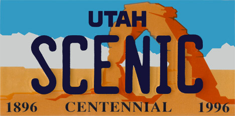
We then headed west some more into Utah, then south to Arches National Park. Similarly to Colorado National Monument, Arches is a large area where erosion created amazing rock formations. If you've seen a Utah license plate, you've seen one of the formations in this park (here's my photo of the same formation from the other side). We were in Arches fairly late in the day, showing up around 7:30 and staying until about 9...even so it, was over 93 degrees the entire time we were there. So, taking the previously mentioned snowball from Mt. Crested Butte, we decided to see what a snowball's chance in hell really is. Here's the before and after pictures. It started melting immediately, but when we came back past about an hour later, there was a tiny bit of ice left, and a small puddle. So, I suppose it's chances are decent for less than an hour, but longer than that, and you've just got a small wet spot.
Anyway, after all that, we headed back up the road to Green River, Utah
where I am writing this from right now...and seeing as it's 12:05 (1:05 AM Central Time), and we're getting up at 6:30 to get on the road early for the long drive tomorrow (Sunday), I should get some sleep. I hope this catches everyone up, if you have any questions about what all we did, I'm checking my email pretty much each evening, and you can email me at LawsonST@gmail.com. As always, the previously mentioned photos, as well as many more (but not all, I've taken 2,237 photos since we left Illinois, and despite flickr's claims that I have unlimited storage, I don't want to subject any of you to all of the photos, which is why I'm only posting a few of the best ones) on my flickr page and hopefully I'll keep up with this blog a little better now that we're on the road again. G'nite.
If you've been looking at my flickr photos here:
http://www.flickr.com/photos/lawsonphotos/collections/72157600510437290/
then you have some idea of what we've been doing. If not, here's a very brief recap (it's 11:30 PM and we have 10 hours of driving tomorrow to Idaho)
Monday - We walked around town and did some shopping and went to a concert in the park in the evening (see previous post).
Tuesday - Adam (my brother-in-law), Jane (my aunt), and Derek (my cousin) and I went golfing down in Gunnison. Sarah went with my parents and sister up to a place called Lake Irwin. While I was golfing, I stepped in a hole and twisted my ankle. I originally thought that it was sprained, but it got better quickly. There are photos of both events on the flickr page.
Wednesday - In the morning, Amy, Adam, and Heather (my cousin) walked and Martha (my aunt), Ted (my uncle), and Gary (another uncle) ran the 8 mile walk/run from Gothic (north of Crested Butte) to the town of Crested Butte. Then immediately afterwards there was a 4th of July parade in town. That evening, we went down to the town to see the fireworks. My ankle was still a little sore, but much better. I was at least able to walk on it without limping.
Thursday - Sarah decided to hang out in the condo and relax, while I went with Martha (previously mentioned aunt) and Heather (previously mentioned cousin) on an approximately 11 mile out and back hike (so about 5.5 miles each way) that went up about 2000 feet of elevation. We turned back a little early because it looked like rain ahead of us, but while we were heading back, we got hit with another storm cloud...quite a bit of rain, got very cold, then started hailing (Colorado hail is much smaller than Illinois hail, it felt more like sleet). We eventually made it back to the car, cold and wet, but I felt a lot better once we got back to the condo and I got a warm shower. My ankle was fine, but I was favoring my right ankle so I wouldn't put more strain on my left (the previously mentioned hurt ankle) and ended up making my right one a little sore.
Friday - In the morning, a bunch of us took a ski lift up to the upper part of Mt. Crested Butte. We started hiking up the rest of the mountain, but only me, my dad, and my sister, Amy made it to the summit at 12,162 feet above sea level, the highest point I've ever been to. Even though the lift took us up about 2/3 of the way to the top (maybe closer, I'm not sure), the rest of the hike was pretty steep (for us Illinois folks) and was hard, although it was pretty much just rocks for the top few hundred feet, and that was actually easier since they didn't slide as much as dirt. On the way down, there was snow, probably at around 12K feet, so I grabbed a snowball and put it in an insulated lunch bag that I had with me...more about this later. After we made it back down, we relaxed at the condo a bit, and then drove up to Taylor Reservoir (big pretty lake) for a look around.
Saturday (today) - we left Crested Butte in the morning a little after 9 AM. We drove from Crested Butte to Green River, Utah, only about 260 miles, but we planned on making quite a few stops at scenic places. Technically, we drove through or stopped and saw four national parks/monuments/recreation areas.
Driving west from Gunnison, we drove through the Curicanti National Recreation Area, which is essentially three large lakes that are formed by a dam in part of the Gunnison River.
After that we stopped at the Black Canyon of the Gunnison National Park, a very deep canyon formed by the Gunnison River. After that, we continued west through Montrose, CO and up to Grand Junction, CO.
Near Grand Junction, we stopped at Colorado National Monument, which was formed when erosion ate away at Monument Mesa and formed huge rock formations.
We then headed west some more into Utah, then south to Arches National Park. Similarly to Colorado National Monument, Arches is a large area where erosion created amazing rock formations. If you've seen a Utah license plate, you've seen one of the formations in this park (here's my photo of the same formation from the other side). We were in Arches fairly late in the day, showing up around 7:30 and staying until about 9...even so it, was over 93 degrees the entire time we were there. So, taking the previously mentioned snowball from Mt. Crested Butte, we decided to see what a snowball's chance in hell really is. Here's the before and after pictures. It started melting immediately, but when we came back past about an hour later, there was a tiny bit of ice left, and a small puddle. So, I suppose it's chances are decent for less than an hour, but longer than that, and you've just got a small wet spot.
Anyway, after all that, we headed back up the road to Green River, Utah
where I am writing this from right now...and seeing as it's 12:05 (1:05 AM Central Time), and we're getting up at 6:30 to get on the road early for the long drive tomorrow (Sunday), I should get some sleep. I hope this catches everyone up, if you have any questions about what all we did, I'm checking my email pretty much each evening, and you can email me at LawsonST@gmail.com. As always, the previously mentioned photos, as well as many more (but not all, I've taken 2,237 photos since we left Illinois, and despite flickr's claims that I have unlimited storage, I don't want to subject any of you to all of the photos, which is why I'm only posting a few of the best ones) on my flickr page and hopefully I'll keep up with this blog a little better now that we're on the road again. G'nite.
Tuesday, July 3, 2007
Day 3 - Crested Butte, CO
So this was our first day in Crested Butte, and we kinda took it easy. We relaxed in the condo for a bit in the morning, then went down to the town to walk around and do a little shopping. We met up with my aunt and uncle and got some pizza for lunch. After doing some more shopping, we went back to the condo to relax for a bit, then went back to town (it's about 3.5 miles in case you're wondering) to see a free concert in the town park by a band from Denver called The Railbenders (here's another image). Here's a shot of all of us who were there. There were some kids that were "dancing" in front of the crowd. Later that evening, we were having dinner in one of the other condos (where more of our group is staying) and we noticed a fox running around the parking lot. Here's a shot of it peering at us from behind my car. After dinner, my mom announced a "baby shower" present for Sarah and Angie (my cousin's wife who is also pregnant, due in November) whereby everyone would decorate onesies for the babies. Here's some of the decorating going on.
As you can see, we kinda took it easy that day, being our first day out and we hadn't really gotten used to the altitude. It's really going to be a big change for Sarah and I, since we'll be here just long enough to get used to it, then we'll be driving down to Portland which is 22 feet above sea level.
And that was Monday, July 2nd.
Subscribe to:
Posts (Atom)